NEW: High Risk Tornado Threat This Weekend
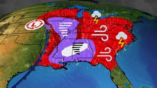
A multi-day tornado outbreak will continue through the weekend in the Midwest, South and East. Strong, long-tracked tornadoes, widespread damaging winds, large hail and flash flooding are all expected during this dangerous bout of severe weather.
NOAA’s Storm Prediction Center has issued a level 4 out of 5 risk of severe weather for Friday, and this threat will only grow to a ‘high risk’ or 5 out of 5 risk of severe weather for Saturday. This threat level is rare, usually only on a severe weather forecast two to three times each year, and is generally used only when supercells are capable of strong tornadoes, or long-lived squall lines are expected to produce widespread damaging winds.
Take this threat seriously and know ahead of time where your safe shelter is and have multiple ways to receive warnings, especially since the severe storms could threaten at night in some locations.
(MORE: News From Across The Central US)
Weather in your inbox
Overnight Outlook
Numerous tornadoes have touched down in the mid-South and Midwest, including several near St. Louis, a damaging tornado in Rolla and one in Hartville, Missouri.
Thunderstorms are expected to continue through the night. By sunrise, a weakened line of thunderstorms should stretch from the Great Lakes to the Tennessee Valley and Deep South.
Swaths of intense damaging wind gusts, tornadoes (possibly EF2 or stronger) and large hail up to the size of baseballs could accompany any storms that turn severe. Tornadoes might spin up within a line of severe storms sweeping across the Midwest and with any supercells that develop in the mid-South.
Severe thunderstorm watches and tornado watches are shaded in yellow and red on the map below, respectively.
Here’s where rain and thunderstorms are right now.

Here’s a look at what to expect each day.
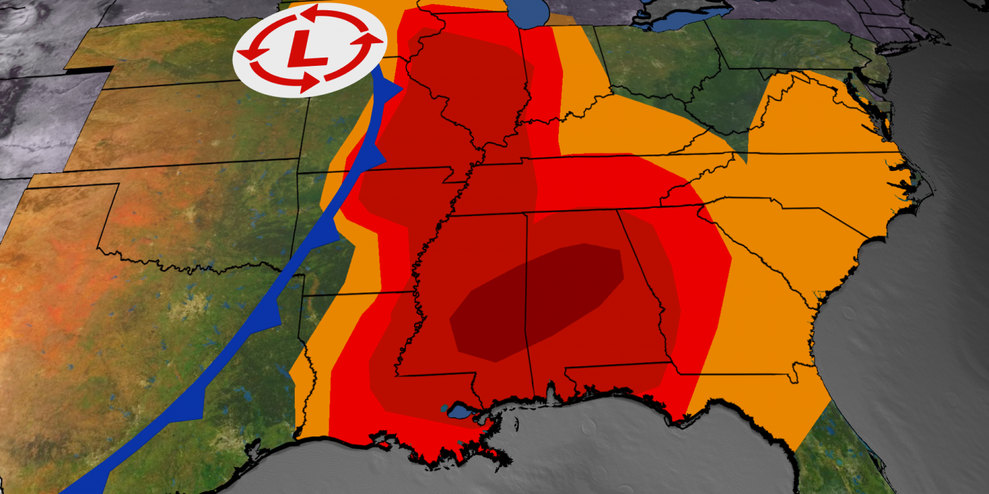
Saturday-Saturday Night Forecast: TORNADO OUTBREAK EXPECTED

Saturday-Saturday Night’s Severe Thunderstorm Forecast
(Shaded on the map above is the likelihood of severe thunderstorms, according to NOAA’s Storm Prediction Center. Note that not all categories apply for the severe weather risk on a particular day.)
-Locations: The Deep South has the highest risk for severe storms, including parts of Alabama, Georgia, Louisiana, Mississippi, Tennessee and the Florida Panhandle. That includes Atlanta; Birmingham, Huntsville and Montgomery, Alabama; Chattanooga and Nashville, Tennessee; Jackson, Mississippi; New Orleans; and Pensacola, Florida.
Zooming in closer, the level 5 out of 5 risk for widespread severe storms is from eastern Mississippi to western and central Alabama. This area includes Birmingham and Tuscaloosa, Alabama; and Jackson and Hattiesburg, Mississippi. This is where atmospheric conditions will be most conducive for producing tornadic supercell thunderstorms. You should be in your storm shelters in this area from mid-afternoon into the evening, if not overnight hours, in this area shaded in darker red above.
At least some severe weather could extend as far north as Ohio, West Virginia and western Pennsylvania.
-Timing: Thunderstorms, some severe, will likely be ongoing in the morning from parts of the South northward to the Tennessee Valley. The most widespread severe weather will unfold in the afternoon and into the overnight hours, spreading from west to east across the threat areas shown above. As an example, the peak threat of severe weather won’t reach the Atlanta metro until the evening or overnight hours.
-Threats: NOAA’s Storm Prediction Center says numerous significant tornadoes, and some long-track tornadoes are expected. In addition, the storms are likely to produce widespread damaging wind gusts and large hail. Flash flooding from heavy rain could impact northern parts of Alabama, Mississippi, Georgia, Tennessee and Kentucky.
(MORE: Nighttime Tornadoes Twice As Likely To Be Deadly)

Sunday’s Forecast

Sunday’s Severe Weather Forecast
(Shaded on the map above is the likelihood of severe thunderstorms, according to NOAA’s Storm Prediction Center. Note that not all categories apply for the severe weather risk on a particular day.)
-Locations: The cold front might produce additional bouts of severe storms from the mid-Atlantic states to the Southeast as the weekend ends. That includes Charleston, South Carolina; Raleigh, North Carolina; Philadelphia; and Washington, D.C.
-Timing: Leftover storms from overnight, some possibly severe, will likely be ongoing in the morning in parts of the East. A combination of those storms possibly intensifying and new storms developing will keep the threat of severe weather going through the afternoon.
-Threats: Damaging wind gusts are the primary concern, but a few tornadoes are possible. Localized flash flooding could also occur in spots.
Classic Setup
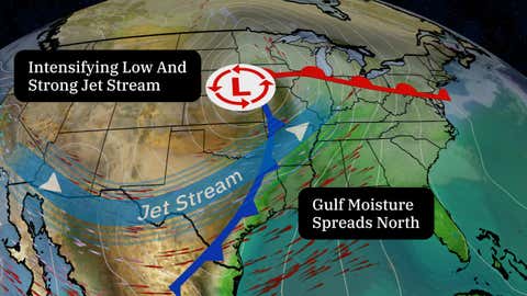
The setup is familiar for March and the rest of spring, with a sharp southward plunge of the jet stream swinging out of the West toward the central and eastern states.
At the same time, the jet stream energy helps to form a strong low-pressure system along a cold front that draws increasing moisture north from the Gulf.
(MORE: Typical Ingredients For An Outbreak)
That combination of ingredients triggers the formation of numerous thunderstorms, some of which could rotate and produce tornadoes in addition to widespread damaging winds and hail.