CNN
—
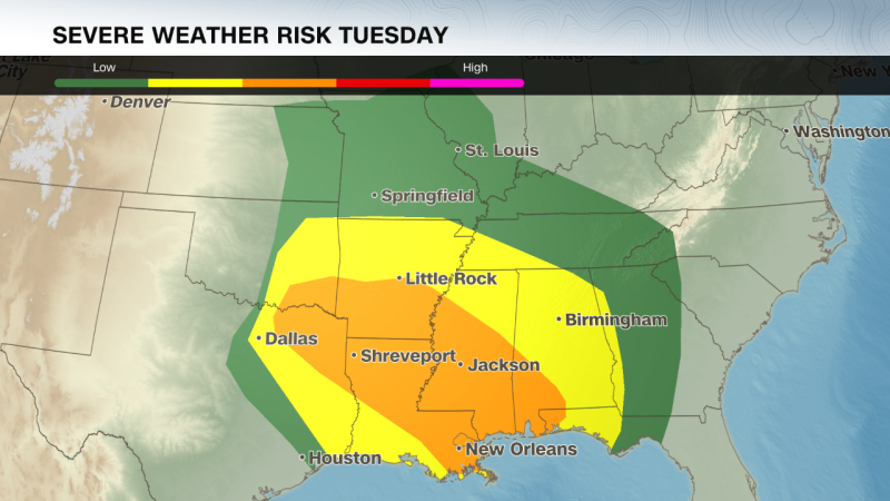
More than 55 million people across the central and southern US are at risk of severe weather on Tuesday as a violent storm sweeps across the country, bringing the potential for blizzard conditions, tornadoes and fire weather.
The dangerous storm is the first major weather event after staffing at the National Oceanic and Atmospheric Administration and its National Weather Service was slashed by the Trump administration –– cuts scientists say will have dangerous consequences for the safety of the American public. Around 800 employees were laid off across NOAA last week.
The powerful storm comes amid Mardi Gras celebrations across the south. In New Orleans, officials rushed to reschedule Mardi Gras day events and shorten parade routes to avoid the potentially destructive weather, according to the Associated Press. A high wind warning is in effect for the city from 9 a.m. to 9 p.m. local time on Tuesday as winds are expected to be sustained at 20 to 30 mph with gusts over 50 mph possible.
A tornado watch was issued for parts of Texas and Oklahoma until 5 a.m. local time Tuesday, with nearly 3 million people affected. Winds up to 70 mph and hail up to 1.5 inches in diameter are also possible as the storm continues to ramp up.
By later Tuesday morning, the storm will increase in intensity as it moves east –– threatening the Lower Mississippi River Valley with strong tornadoes, gusty winds, large hail and heavy rainfall. These storms are expected to last into Tuesday night, which can lead to especially dangerous nighttime tornadoes.
Northern Louisiana, central Mississippi and southern Arkansas will likely experience the worst severe weather Tuesday. Some strong tornadoes, wind gusts over 74 mph, and large hail are possible for cities like Shreveport, Louisiana and Jackson, Mississippi. These storms will likely bring heavy rainfall totaling as high as 3 inches.
A lower threat for severe storms will spread from eastern Texas to western Georgia, extending north through most of Missouri. The lower threat of storms could bring isolated tornadoes, gusty winds and hail to Memphis, New Orleans, Baton Rouge, Atlanta, Dallas, St. Louis and Kansas City.
Officials in New Orleans are keeping a close watch on the coming storms. Some Mardi Gras parade times have been moved and durations shortened as police look to ensure that the hundreds of participants and dozens of floats move along quickly this Fat Tuesday — before winds pick up, the Associated Press reported.
Gusts in New Orleans could reach 60 mph, the National Weather Service said, warning that Mardi Graf floats “could become unstable” amid the ferocious winds.
Two of the city’s largest parades — organized by the Krewe of Zulu and the Krewe of Rex — were still scheduled for Tuesday morning, according to CNN affiliate WVUE. But both parades will follow shortened routes, and police are giving revelers a hard out.
“Parading is over at 11:30 (a.m.),” New Orleans Police Superintendent Anne Kirkpatrick said Monday. “Have a great time, but at 11:30, you’re out of here.”
Kirkpatrick warned she will pull the plug on festivities entirely if the weather worsens. “I hold that trump card in which I will not hesitate to cancel — I won’t do it lightly, but I will do it,” she said.
Officials have already taken that step in neighboring Jefferson Parish, where at least two parades have been canceled because of the expected high winds.
“Loose items could get blown away and high-profile vehicles, including Carnival floats, will have dangerous crosswinds,” the parish said in a statement released Monday.
“This is disappointing, but our top priority is ensuring the well-being of everyone in our community, and we must always prioritize safety above all else,” Jefferson Parish President Cynthia Lee Sheng said. The parish said it will work with the krewes to try to reschedule the parades.
The strong March storm is bringing a different threat to the central US. Snow has already started to fall on the Rocky Mountains and winter weather alerts blanket the region.
In the Denver Metro area, a mix of rain and snow was seen Monday and was expected to continue, according to the National Weather Service. A blizzard warning is in effect from midnight Monday to 2 p.m. local time Tuesday for parts of Colorado’s Elbert and Douglas counties above 6,000 feet.
Some blizzard conditions are also expected across parts of the Central Plains beginning Tuesday morning, with snowfall totals potentially reaching a foot. Winds could gust as high as 65 mph, which could cause blowing snow and rapid drops in visibility. Across the higher elevations of Colorado, snowfall totals over a foot are also possible.
Snowfall will eventually move into parts of the Midwest by Tuesday evening, where winter weather alerts will be in effect for parts of Iowa, Wisconsin and Minnesota beginning Tuesday evening. Here snowfall of 2-7 inches is possible through Wednesday afternoon.
A massive dust storm, meanwhile, swept over swaths of New Mexico, Texas and Mexico on Monday morning, bringing violent winds and cloaking roadways in near-zero visibility.
Officially called a haboob, the fast-moving wall of dust and debris prompted New Mexico officials to close parts of Interstate 10, where the sudden curtain of low visibility appears to have forced some vehicles off the road.
Video taken by a passing truck driver near the city of Deming, New Mexico shows emergency vehicles positioned around a tangle of stopped vehicles, including tractor trailers and an RV-towing pickup truck. Debris is seen scattered across the highway.
“You can see where everything got blown off the road,” truck driver Toby Bogard said in the video shared with CNN. “I hope everyone is alright, but if you’ve never seen a sandstorm called a dust storm out here, this is one.” he added.
Katlyn Stephens and her family were driving on Highway 54 from New Mexico to Texas on Monday morning when their car was suddenly engulfed by the dust storm.
“It was just crazy, we just coasted through,” Stephens told CNN. “It wasn’t until we went through a couple of hills that we knew we were going into something crazy.”
Stephens said her husband, who was at the wheel, was cautious of what was ahead –– occasionally stepping on the brakes to avoid a crash.
The dust storm is expected to worsen fire conditions in the Southern Plains, where strong winds, dry air and ongoing drought are already present.
More than 8 million people across Oklahoma, Texas and New Mexico are under red flag warnings. Parts of western Texas are under an exceptional drought –– the highest level from the US Drought Monitor. If any new fires start, they may spread out of control, the monitor warns.
Central and southwestern Texas are expected to be at the highest risk of fires Tuesday, according to the National Weather Service, which issued an “extremely critical” fire threat for the region. Southeastern New Mexico has also been raised to a “critical” fire weather alert.
Cities like San Antonio and Austin could experience gusts up to 60 mph and single-digit humidity levels through the day, further heightening the danger of fires.