
CNN
—
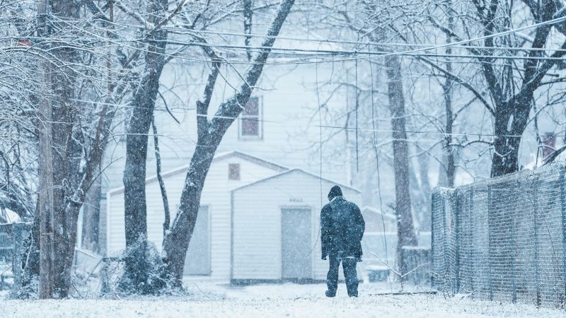
The first of this week’s back-to-back-to-back winter storms is bringing snow, ice and rain to a 1,500 mile stretch of the eastern US Tuesday morning.
Another winter storm will hit some of the same areas in quick succession and dump the most substantial snow of the season over Chicago. The third storm is the most serious flood threat Southern California has faced since January’s devastating wildfires.
Each is another link in a chain of disruptive storms unbroken since the start of February.
Here’s the latest:
• Snow will pile up: It’s snowing over parts of the Tennessee Valley and Appalachians Tuesday morning, where 1 to 3 inches have already fallen. There’s more to come into Wednesday morning as the storm tracks east. Washington, DC, could get up to 6 inches of snow Tuesday which could snarl travel during the afternoon commute.
• State of emergency and school closures: Virginia Gov. Glenn Youngkin declared a state of emergency, and the Virginia Department of Transportation urged residents to “stay off the roads once the storm arrives.” Several schools in the state are closed. Schools in the DC area and Maryland also announced early dismissals and closures, citing anticipated disruptions, along with similar impacts at schools in Kentucky, North Carolina, Ohio and Indiana.
• Power outages and treacherous travel likely: Significant amounts of ice – more than 0.25 inches – are possible through Wednesday in parts of West Virginia, Virginia and North Carolina. “Ice accumulations could make many roads treacherous and impassable,” the National Weather Service warned Tuesday. “The weight of ice on tree limbs and power lines could produce numerous outages.”
Tuesday’s storm is tracking farther south than either of last week’s and putting areas that avoided a wintry mess right in the thick of it.
A band of snow is falling north of an area of the Appalachians expected to get the worst ice. Heavy snow could fall and pile up quickly in some areas, including Washington, DC. New snow will add onto an already impressive winter total to date. As much snow has fallen in Washington, DC, since December 1 as in the past two winters combined.
Snow will also blanket parts of Pennsylvania into New Jersey and southern New England. New York City will likely see an inch or two of snow.
Heavy rain is drenching an area to the south on the warmer side of the storm. There’s a risk of flooding over a wide area of the South through Wednesday. A level 2 of 4 risk is in place for parts of every state from Texas to the Carolinas — including many areas still recovering from Hurricane Helene — during this time, according to the Weather Prediction Center.
Storm two: Wednesday and Thursday
The next storm will form in the central US while its predecessor is still bringing snow and ice to the East and rain to the South. Snow, ice and rain are expected in the Plains overnight Tuesday into Wednesday morning.
Kansas Gov. Laura Kelly issued a state of disaster emergency proclamation on Sunday due to the storm.
The wintry mess will quickly expand Wednesday to encompass much of the Midwest and parts of the Northeast by the evening.
The bulk of the storm will be on the East Coast by Thursday morning with snow and ice blanketing the Northeast and rain falling farther south. Some parts of the East will only have a few hours between when the first storm ends and the second begins.
Snow totals from this storm will be highest in the Plains and Midwest. They could approach double digits in Kansas City, Missouri, on Wednesday – close to double what the city typically gets in all of February.
Double-digit snow is also possible in Chicago Wednesday, which would be enough to be the city’s most substantial so far this season. Just over 7 inches of snow have fallen since December when the city typically records almost two feet by now.
Ice will present a significant problem again just south of where the heaviest snow falls. At least a light glaze of ice — enough to make travel tricky — is possible anywhere from Oklahoma and Kansas through the Ohio Valley and Northeast.
Parts of the Appalachians will get another round of ice from this storm. A few of the locations hit hardest from the first storm might not notice a break between the two storms as icy precipitation slows but doesn’t completely stop Wednesday afternoon.
This storm will reinvigorate rain and thunderstorms in the South Wednesday. Some thunderstorms could turn severe in parts of Louisiana, Mississippi and Alabama starting in the afternoon and a Level 2 of 5 threat is in place.
The storm will largely come to an end by Thursday night.
This storm will be different than the previous two in that it will first slam into California fully formed.
The atmospheric river-fueled storm will pack a significant punch and from the start with rain beginning along much of the state’s coast early Thursday morning. Rain will get heavier throughout the day as it reaches farther inland and spreads over the entire length of the state.
Portions of California’s Los Angeles and Ventura counties – including areas burned by the Palisades and Eaton fires – are under a Level 3 of 4 risk of flooding rainfall Thursday, according to the WPC. More than 35 million in the rest of the state are under a level 2 of 4 risk of flooding rainfall Thursday. The threat area encompasses San Francisco, Sacramento, San Diego and areas in between.
Heavy rain presents an even greater risk to areas burned by recent deadly wildfires.
“This storm has the potential to bring life threatening debris flows in and below recent burn scars,” the NWS in Los Angeles warned Monday. An inch or two of rain is possible over the Los Angeles basin.
The threat to the burn scar areas comes as officials are tackling the effort to remove hazardous debris left behind by the fires. Los Angeles County recently bolstered storm preparations by cleaning debris basins, installing concrete barriers, and placing sandbags in fire zones to filter debris and protect storm drains.
This storm will also bring heavy snow to California’s Sierra Nevada and mountainous areas of the West. It will track east Thursday night and Friday and reach the Plains by early Saturday morning.
A boost of atmospheric energy will reinvigorate the potent storm and significantly expand its size once it reaches the central US. Snow will blast over the Midwest Saturday and reach much of the Northeast by the evening. Some sleet and ice may mix with snow in the Northeast with mainly rain drenching areas farther south Saturday night.
Heavy rain and thunderstorms will dominate the warm side of this storm. Some thunderstorms could become severe, especially in parts of the South. Dangerous thunderstorms can happen at any time of the year – some turned deadly last week in Tennessee.
The large storm will continue to pound the East Coast Sunday before coming to an end by Monday morning. But it may not be the end of a busy winter storm pattern as another storm is possible by the middle of next week.
CNN’s Hanna Park and Stephanie Elam contributed to this report.


Leave a Reply