
CNN
—
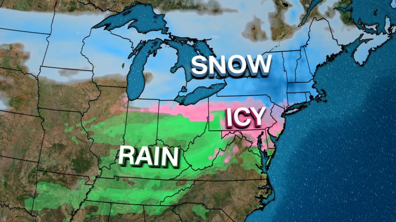
A fast-moving winter storm packing a dangerous combination of snow, sleet and ice is moving through the Midwest on Saturday afternoon, with up to a foot of snow predicted in parts of the Northeast by Sunday morning.
Over 84 million people from the Midwest to the Northeast are under extensive winter alerts, according to the National Weather Service. The storm is already causing flight delays and it may bring dangerous traffic conditions and power disruption.
More than 2,400 flights within, into or out of the US have been delayed Saturday, according to flight tracking website Flight Aware. And more than 470 flights have already been canceled.
“Due to a winter storm across the northeast, Boston Logan expects delays and cancellations,” the airport said Saturday afternoon.
On the ground, the storm will produce “hazardous travel due to low visibility, snow-covered and slippery roads. Power outages and minor tree damage are possible where ice is the heaviest,” the weather services warns.
By Saturday night, up to 8 inches of snow are expected in parts of the Upper Great Lakes. As the storm pushes eastward through Sunday morning, upstate New York and southern New England could see up to a foot of snow. Meanwhile, a wintry mix of snow, sleet and freezing rain is forecast from the Ohio Valley into the northern Mid-Atlantic, with light ice accumulations expected.
“This storm could create dangerous travel conditions with near-zero visibility at times,” New York Gov. Kathy Hochul warned Friday as she declared a state of emergency. The governor activated emergency protocols, including accelerated salt deliveries, and waived trucker hour limits to expedite road treatment.
The storm system is moving in two rounds: The first is bringing heavy snow to the Midwest on Saturday afternoon, followed by significant snowfall in parts of the Northeast, coupled with icy conditions in the Appalachians.
Where to expect snow and ice
Multiple weather systems will be affecting the Northeast over the next 72 hours, the NWS Northeast River Forecast Center said on X Thursday. Below-normal temperatures are likely across much of the continental US for the next few weeks, the agency said. This combination of active weather and prolonged cold may bring a continued stretch of winter disruptions for many Americans.
Here are the major city impacts, as of Saturday afternoon:
- Green Bay, Wisconsin: Winter storm warning until 9 p.m. Saturday, 4-8 inches of snow expected
- Chicago: Winter weather advisory until 7 p.m. Saturday, freezing drizzle accumulating up to 0.1 inch
- Cleveland: Mixed precipitation expected, with up to 1 inch of snow and sleet, and up to 0.2 inches of ice accumulation from 1 p.m Saturday to 1 a.m. Sunday
- Washington, DC: Winter weather advisory until 7 p.m. Saturday, expecting mixed precipitation with up to 1 inch of snow and sleet
- Philadelphia: Winter weather advisory from noon Saturday to 6 a.m. Sunday, with a chance of snow turning into a rain and sleet mix after midnight
- New York City: 3-5 inches of snow and sleet expected after 6 p.m. Saturday
- Boston: Winter storm warning after 10 p.m. Saturday, with 4-7 inches of snow expected
The storm’s timing coincides with Super Bowl weekend, potentially complicating travel plans for fans heading to New Orleans. Airports in major hubs like Chicago, Detroit and Boston are preparing for delays and cancellations due to snow and ice over the weekend.
Nearly 300 flights within, into or out of the US have already been canceled on Super Bowl Sunday, according to Flight Aware.
The weather service warned Saturday that dense fog near airports in Louisiana may complicate arrivals for thousands of fans traveling to New Orleans for Sunday’s game. But those in The Big Easy celebrating football festivities will enjoy mild weather with highs in the low 80s.
Two more systems are on the horizon for next week, with another Arctic blast expected to push temperatures 10 to 20 degrees below seasonal norms across the Northeast. Meteorologists attribute this active pattern to the positioning of the jet stream, which is funneling storms across the northern US.
The jet stream, essentially a river of air in the atmosphere that storms flow through, is locked in an almost perfect line from west to east, and will continue to funnel fast-moving storms across the northern tier of the Lower 48.
This pattern has been responsible for maintaining lower-than-average temperatures across much of the country this winter. New storms are expected to arrive every few days until the jet stream shifts — something that might not happen until the second half of February.
This weekend’s storms are just part of what forecasters expect will be an active February for winter weather.
CNN Meteorologist Mary Gilbert and Dalia Faheid contributed to this report.


Leave a Reply