
CNN
—
A mammoth and multifaceted storm – which was dealing wind, fire, choking dust and the threat of a blizzard – is pummeling much of the country as it marches east overnight.
The powerful storm is set to reach the East Coast on Wednesday, bringing potential impacts from Florida to New York. The strongest storms are expected from Charleston, South Carolina up to southern Virginia, which could see damaging winds and tornadoes.
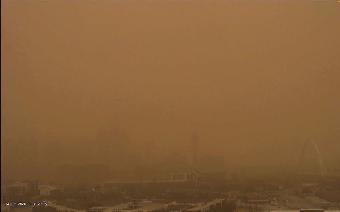
On Tuesday, the sky over Dallas resembled a Martian landscape as winds kicked up red dust, sparking fires across much of dry Texas. At least 15 fire reports have been received by the National Weather Service office in San Antonio and Austin.
The blazes came as near-record low pressure in the Midwest is bringing strong winds across much of the country, from the Plains to the Southeast. At least two people are dead in Mississippi’s Madison County after storms swept across the state on Tuesday. Coroner Alex Breeland told CNN one person was electrocuted and another died when a tree fell on a car.
Here’s the latest:
• Deep South feeling the punch: A line of damaging storms moving through Alabama, Georgia and the Florida Panhandle overnight will continue to head east Wednesday, bringing a threat of strong winds and a few tornadoes.
• East Coast braces for impacts: The storm is expected to bring its strongest to the Carolinas and Mid-Atlantic by Wednesday afternoon, bringing strong winds and a chance of tornadoes from Charleston, South Carolina, up to Norfolk, Virginia. Lower storm threats are possible from Florida to southern New York, which could see gusty winds, rain and hail.
• Fires in Texas: Dozens of fires have erupted across Texas amid a critical fire risk across a large portion of the state. High winds in Atascosa County resulted in several house fires Tuesday afternoon, law enforcement officials said.
• Blizzard conditions possible: Heavy snowfall and gusty winds will remain across the Midwest through Wednesday afternoon. This will mean possible blizzard conditions in more populated areas, including Kansas City, Omaha, Nebraska; Des Moines, Iowa; and perhaps Minneapolis. Gusts of 50-70 mph are expected in some areas.
• Widespread power outages: Severe thunderstorms with intense damaging wind gusts are roaring across the South. Wind gusts in excess of 70 mph have occurred in states, including Texas and Oklahoma. More than 500,000 homes and businesses were without power across central US, the Southeast and parts of the Midwest by early Wednesday, according to PowerOutage.us.
• Dust storm: Officially called a haboob, the fast-moving wall of dust and debris was still blowing across the region Tuesday as strong winds moved across the region, especially in Texas. The winds have since died down from 45 mph to below 10 mph across much of the region.
Significant damage in Texas and Oklahoma
Severe thunderstorms caused significant damage Tuesday to buildings and created hazardous conditions across several cities in Texas – including the Dallas-Fort Worth metro area – and Oklahoma.
The Benjamin Moore paint storage in Lewisville – 25 miles north of Dallas – was damaged in the early hours of Tuesday, “prior to any of our employees being on the property,” its spokesperson Kimberly Flores told CNN. “None of our employees were injured and we are currently assessing the damage and implications to our operating procedure.”
In Plano, just north of Dallas, strong winds tore off part of a high school’s roof, according to CNN affiliate KHOU. Heavy rain flooded its sports facilities, disrupting practices, KHOU reported citing Plano police. Despite the damage, no classrooms were affected, and classes will continue Tuesday. Classes continued Tuesday despite the damage, the district said.
In nearby Irving, police confirmed significant storm damage, including downed power lines.
Just north of Austin, Williamson County has seen at least eight fires, though most have been contained by first responders, the county’s Office of Emergency Management said on X.
Over 210 storm reports, including seven EF1 tornadoes – a category comprising wind speeds from 86 to 110 miles per hour – have caused damage from Texas to Mississippi. Winds topping 55 mph threaten 100 million people from Texas to the Carolinas.
An EF1 tornado tore through a community in Ada, Oklahoma, on Tuesday morning, according to the National Weather Service. Images on social media showed toppled structures and widespread destruction.
Byng Public Schools near Ada canceled classes Tuesday due to “multiple bus routes that cannot run due to damage and debris on roads” and power outages, according to an update on Facebook.
The storms have also disrupted air travel: About 800 flights within, into or out of the US were canceled and nearly 4,000 were delayed by late Tuesday evening, according to FlightAware.
Strong winds – gusting to 56 mph – at Dallas Fort Worth International Airport led the Federal Aviation Administration to issue a ground stop for departures there Tuesday afternoon.
About 8 million people in the Carolinas and southern Virginia are under a level 3 of 5 risk of severe thunderstorms. Storms in this area could unleash damaging wind gusts in excess of 75 mph and tornadoes.
A tornado watch remains for southwestern Alabama, the Florida Panhandle and southeastern Georgia until 6 a.m. CST on Wednesday.
Nighttime tornadoes are nearly twice as likely to be deadly as those occurring during the day, a 2022 study found.
More than 29 million people from Florida to Pennsylvania – including Washington, DC, and Baltimore – are under a lower threat — level 2 of 5 — of severe thunderstorms, according to the Storm Prediction Center. Damaging wind gusts and a few tornadoes are possible within these storms.
Much of the storm’s precipitation will come to an end Thursday, but gusty winds will persist in its wake.
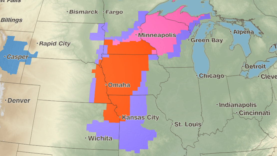
Across the northern end of the storm, blizzard conditions are expected in the central US on Wednesday morning as it moves over Nebraska, Iowa and Minnesota.
“Travel should be restricted to emergencies only,” the NWS office in Iowa warned on Tuesday night. “If you must travel, have a winter survival kit with you. If you get stranded, stay with your vehicle.”
Meanwhile, forecasters in Minnesota and Nebraska cautioned that heavy snowfall could produce whiteout conditions, making travel “treacherous and potentially life-threatening.”
Blizzard warnings will expire for the central US and the Midwest by Wednesday afternoon, where snowfall totals of 4 to 8 inches and gusts to 65 mph are possible from eastern Nebraska to southern Minnesota. Across parts of Wisconsin and northwestern Michigan, winter weather alerts are in place until early Thursday, where snowfall totals over a foot and gusts to 45 mph are possible.